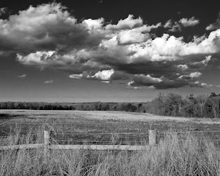
On monday a large storm front moved through the Charlott, NC region. The wind was blowing hard and the clounds kept coming in waves. They would string out in a long line and you could see where the change in temperature was in the atmosphere. The hot and cold spots along with the raving wind created these very fluffy and detailed clouds. There were ominous dark bottoms with bright spiking tops. These weren’t tall thunderclouds that reach so high, but they were low and concentrated.
I was admiring them while driving down I-485 and I found a spot off one of the exits that was still natural looking. It had a high bank where I could perch and take the shot. I carry my Leica digital with me everywhere because you never know.
This shot was the fifth one I took. The sun was behind me and it was hard to find an angle that gave me the view of the clouds I wanted without putting my shadow in the picture. Eventually I squatted down and turned just enough to avoid the shadow.
This image was shot at 1/250 and f/8.0. Of course I converted it to black and white. The sharp whisps of the clouds standing out on the dark background of the sky is what makes this photo for me. It looks like we kept the rule of thirds all around (the sky vs. ground, trees vs. field, etc.). We even keep a little bit of the ‘V’ between the angle of the clouds and fence posts.
The only change I would make, would be a wider angle lens that could capture more of the clouds. All in all, a keeper.
